No cities in the world have a greater value of assets vulnerable to rising sea levels than do Miami and its barrier island vacation paradise Miami Beach.
As part of a studio to find design solutions for climate change mitigation in the Miami region, I am working on a plan to turn a public golf course into a wetland public park designed to absorb regular flooding. By developing high density buildings that capitalize on the amenity of the new park and are designed to resist flooding, the project could turn a sitting duck into a resilient asset for the city.
The banks of the Schuylkill River are developing rapidly, with high-density residential and office towers forming a new Philadelphia skyline.
On the east back of the Schuylkill, bounded by the Schuylkill River Trail, Cherry Street, 23rd Street, and JFK Boulevard, is a large lot that is currently occupied by surface parking.
As part of an ongoing class on the real-estate development process, I took this lot through the paces of re-development, creating a pro forma, a design, and a narrative to sell the project.
My plan calls for:
+ Two twenty-story residential and hotel towers, one facing the city skyline and the other facing the river, situated on three-story parking podiums.
+ A row of townhomes facing 23rd Street with small private yards.
+ A playground—a sorely needed neighborhood amenity.
+ A river-facing seasonal cafe.
+ A unique performance and event space on the southern third of the site, which is crossed by a large stone rail viaduct.
The Philadelphia neighborhood of Mantua is pockmarked by vacancy and characterized by deteriorating rowhouses.
Yet the neighborhood is also in the path of powerful market forces, especially the expansion of Drexel University to the south, that current residents fear will ultimately displace them.
The time is past due for the attention of city officials and developers to work to resolve Mantua’s issues and fulfill its promise.
As part of a class assignment, I developed a plan for a program of infill housing in Mantua. To find the appropriate site, I conducted a field survey of the assigned area, and mapped housing condition (second plan), vacancy (third plan), and tree cover (fourth plan). Using my observations and other research I developed a site approach diagram (fifth plan) to help visualize the factors at play in the neighborhood. The result was a infill housing strategy (top plan) that targeted the part of the neighborhood least likely to develop on its own and most in need of help.
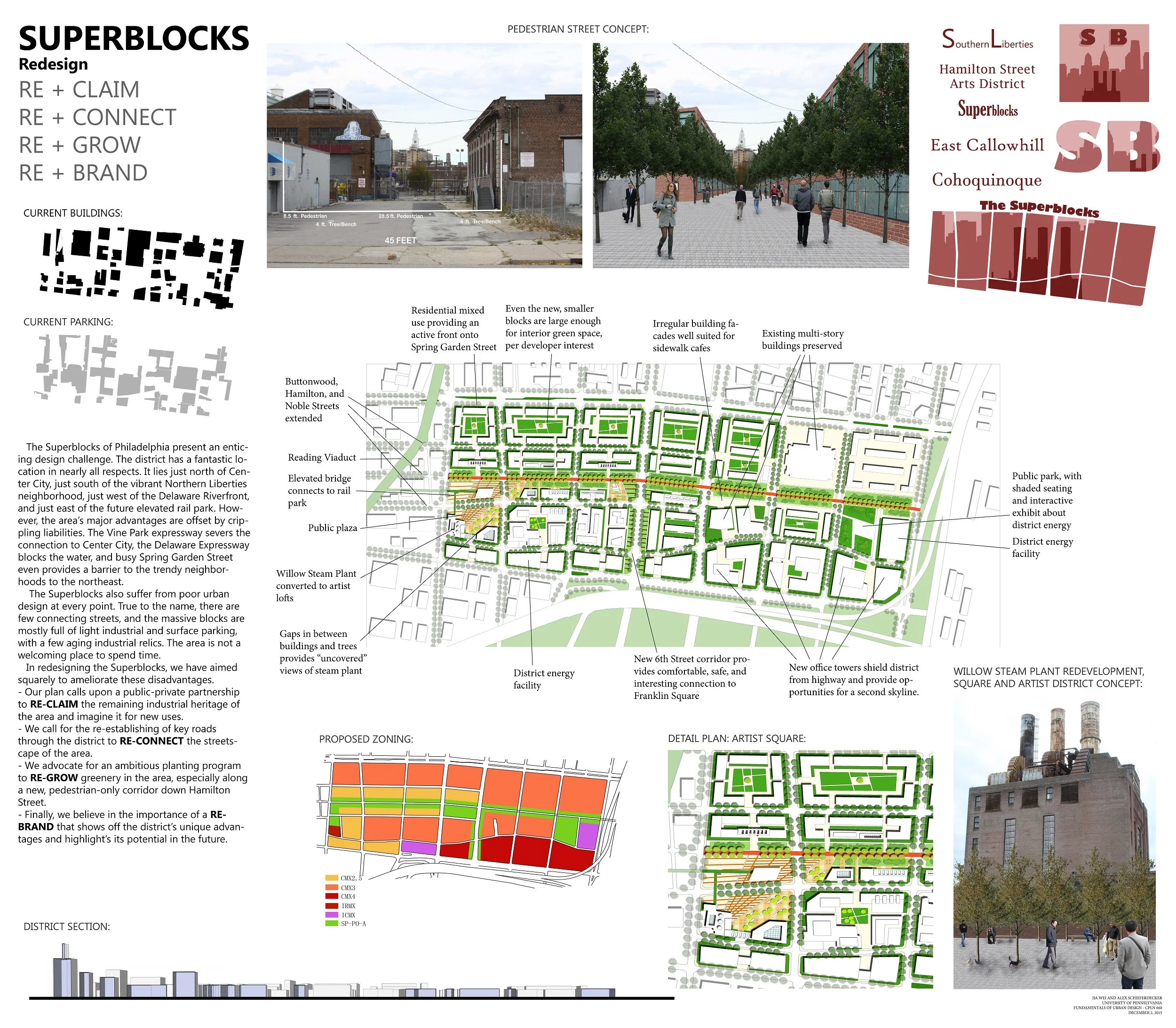
Just to the north of Old City, Philadelphia is a dreary district characterized by superblocks of light industrial uses and cut off from the river and the central business district by the interstate highway.
The neighborhood’s obvious unrealized potential was fodder for a class assignment to develop a master plan for the entire district. Working with another student, we produced a plan that called for restoring the area’s street grid, rehabilitating a signature piece of industrial architecture as artist housing, and creating a pedestrianized central axis to connect the entire neighborhood to the under-development Philadelphia Rail Park.
Minneapolis-St. Paul has been investing in a light-rail and improved bus network since 2004. An informal group of designers and transit enthusiasts led by Kyril Negoda had developed an open-source transit map for the Twin Cities years earlier, chronicling their work on the blog Mapping Twin Cities.
For the purpose of an article looking at the near and long-term future of the MSP METRO system, I updated that earlier map, adding three new lines, four new bus routes, and making a host of other minor edits and updates.
Currently only the blue and green lines exist or are planned. I reviewed lines proposed by local advocates and sifted through demographic data to inform my proposals. The new proposed routes serve major centers of population outside of the core downtown areas, and also adhere closely to existing freight railroad right-of-way in order to reduce costs of building such a system.
For much, much, more on this project, see my blog post: Three Complaints and Three Ideas for Minneapolis-St. Paul's Future METRO System.
The Bicycle Coalition of Greater Philadelphia set a goal to triple the city’s bicycle mode share. I helped develop an infrastructure plan to make that happen.
This vision was anchored by a loop around center city of the highest quality off-street or protected bicycle lanes, intersecting with more conventional on-street facilities. In a series of schematic maps intended for a slide presentation, I showed the completed vision, as well as the currently completed routes (second plan, dotted lines represent existing routes that would be upgraded), the routes that are in the works (third plan), and the works that still need public support and funding (fourth plan).
The Strawberry Mansion neighborhood, in North Philadelphia, is among the city’s poorest, yet development is increasingly occurring along its fringes.
As part of a neighborhood planning workshop, I made a number of perspectives to demonstrate alternative futures for Philadelphia’s Strawberry Mansion neighborhood.
This perspective (top) shows a block of infill housing on a distressed block (current condition shown below); a key component of my group’s “Urban Village” strategy, which called for investments in housing and preserving and adding to the historic rowhouse character of the area.
The Strawberry Mansion neighborhood, in North Philadelphia, is among the city’s poorest, yet development is increasingly occuring along its fringes.
As part of UPenn’s second semester planning workshop, I made a number of perspectives to demonstrate alternative futures for Philadelphia’s Strawberry Mansion neighborhood.
This perspective shows two aspects of our "Commercial Hub" plan. In the foreground is a re-used industrial building, transformed into a retail hub and center for entrepreneurship. In the background, the retail is continued along a bridge that spans a wide railroad trench—a solution inspired by the Ponte Vecchio in Florence and a similar project in Columbus, OH.
Shown to the left are cover page designs I made for studio class presentations.
The top design, for a neighborhood planning workshop, features a stylized outline of the Strawberry Mansion neighborhood. The white lines are major streets through the neighborhood. The photographs in the cracks roughly correspond to where they were taken in the neighborhood itself. I designed the photo collage image, which was used for all presentations and the final book. Another student designed the title text for this final image.
The middle design, for a transportation planning studio in Querétaro, Mexico, features a bicycle icon that uses both wheels to help spell "Querétaro". The accent on the "é" is subtly implied by the pedal. I used this design for my own, in-class presentations.
The bottom design, for a resillience-focused public realm studio in Miami, emphasizes the importance of water in the world's most vulnerable city to sea level rise.
On Twitter: @alexschief