This work has been featured in MSP Mag!
A few weeks ago, I surveyed the state of downtown Minneapolis by mapping its streetscapes. That project received a positive reception, and a few people asked me to use the same approach and look at downtown St. Paul.
The smaller of the Twin Cities has a much, much smaller downtown. Geographers have spent a lot of time and energy looking at the relationships between various spatial units in a given region and have generally found that with each decreasing rank, there is an order of magnitude difference in size between these units. A similar relationship seems to hold in the Twin Cities, where downtown Minneapolis boasts over 160,000 jobs, of which nearly 150,000 are private. In contrast, a generous drawing of downtown St. Paul encompasses just under 70,000 jobs, of which a touch over 40,000 are private (all data from OnTheMap). The relative difference in residential population is even greater.
If not exactly bustling, downtown St. Paul still remains relevant. It is within the top 100 largest job centers in America and the second largest in the region. It has a skyline of its own and two professional sports teams. It hosts the region’s primary Amtrak and intercity bus station. It is also receiving much-needed investment that will turn it into a burgeoning local transit hub. By 2030 or sometime soon thereafter, it could be served by two light rail lines, two bus rapid transit lines, and two arterial buses.
Downtown St. Paul has also benefitted at times from flying under the radar. At the same time that the era of urban renewal eviscerated downtown Minneapolis, downtown St. Paul survived with more of its historic fabric remaining. Today, those structures form the core of its appeal.
Even more so than major downtown business districts, the future is really uncertain for secondary business districts like downtown St. Paul. But whatever societal trends occur, what all of these places need will remain the same thing: more activity. More homes, more jobs, more storefronts, and more things to do.
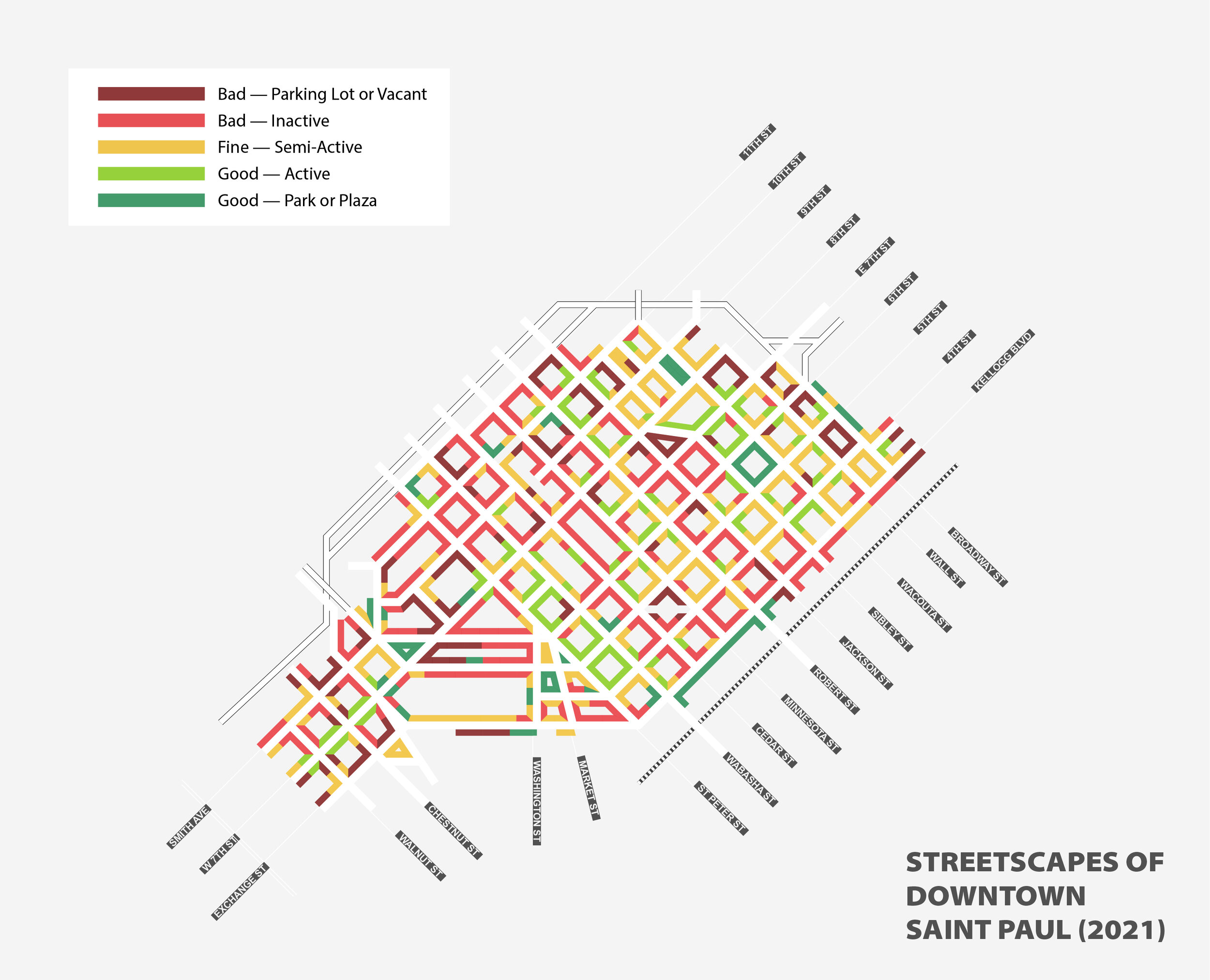
Mapping The Streetscapes
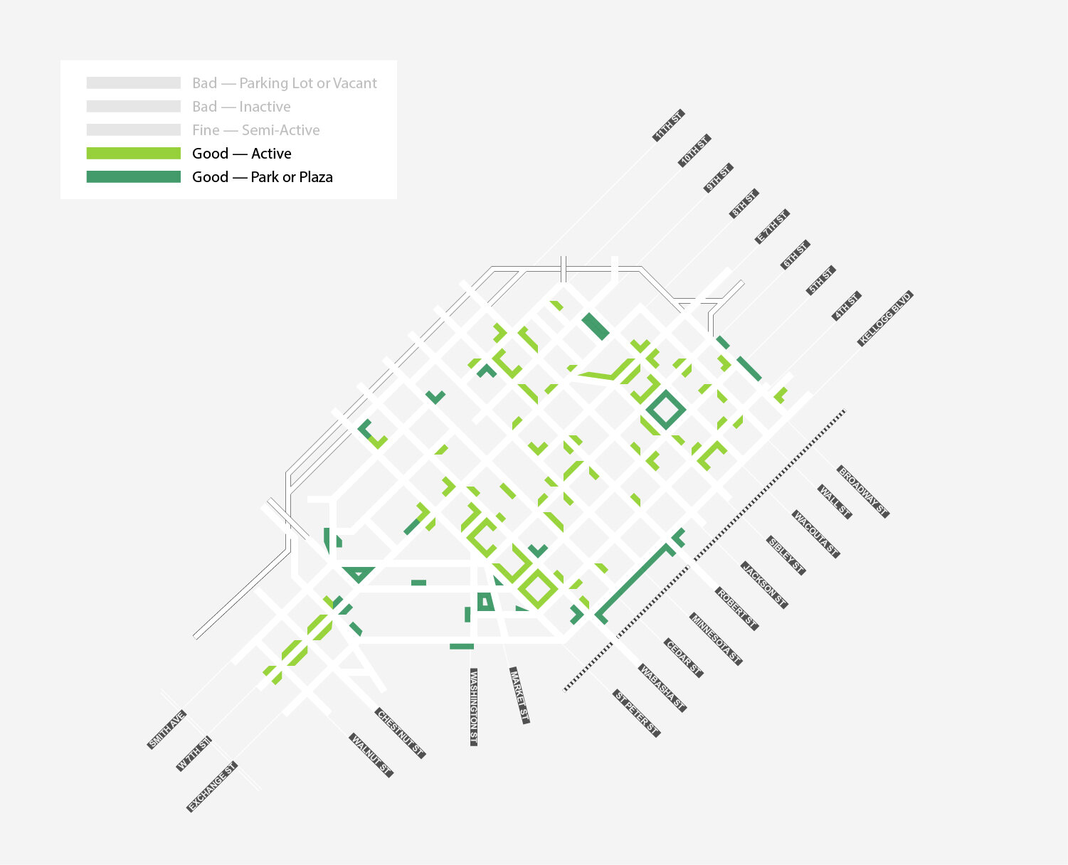
As I did with Minneapolis, my method was to evaluate every streetscape (full map at the end) in downtown St. Paul from the edge of Lowertown to the edge of West 7th, and otherwise bounded by the river and the highway. I gave each streetscape one of five grades based on activity and interest of the ground floor:
Bad (Surface Parking or Vacant): Entirely or predominantly a surface parking lot, or vacant.
Bad (Inactive): A blank wall, opaque windows, or a fence.
Fine (Semi-Active): A building with transparent windows, a non-retail use, or nice landscaping.
Good (Active): A building with a retail use and doors to access it, or sidewalk dining.
Good (Park or Plaza): Entirely or predominantly a publicly-usable green space or plaza.
To repeat a couple of caveats, I didn’t make a distinction between retail spaces that were or weren’t occupied, because that is always changing. I did grade the finished streetscapes of projects that are still under construction; in this specific case that applies to the residential and hotel development across from the Xcel Energy Center.
Also keep in mind that these categories aren’t detailed enough to perfectly fit with every possible situation. For the sake of consistency, I sometimes awarded “Good” scores for streetfronts that I don’t find especially welcoming, and “Bad” scores for streetfronts that I find attractive. But in general, the scoring system holds up, and across the entire downtown I believe that its generalized assessments are fair.
The Best and the Worst Of Downtown
With all that out of the way, let’s look at the best streetscapes in downtown St. Paul:
The old saw is that downtown St. Paul has America’s two best downtowns with America’s worst downtown in the middle. I think this exercise partially supports that. But it feels more accurate to say that downtown St. Paul has one great downtown neighborhood and two smaller loci of activity.
Downtown St. Paul’s crown jewel is Lowertown. I think it has a case for being the best neighborhood in the Twin Cities. As this map shows, it boasts a great collection of active streetscapes, mostly bars and restaurants, especially around the edges of the fantastic Mears Park. There is an enormous opportunity in my mind for creative developers to add more infill and bring the neighborhood a few more everyday retail options.
Downtown St. Paul’s other gem is just east of Rice Park, the Landmark Center, and the St. Paul Hotel. This map highlights the great string of businesses along and branching off St. Peter Street. But the entire area is really small, at most only six or so blocks. While Lowertown is something of a modern reinvention, the Rice Park area is more like the last vestige of old St. Paul that hung on through the last century and could form the nucleus of something great again.
The newest area of interest in downtown St. Paul is the cluster that is growing around West 7th Street. The influence of the nearby Xcel Energy Center is obvious in the number of sports-y bars, but this retail strip has been adjacent to residential neighborhoods for almost as long as St. Paul has been a city, and so there’s some businesses serving local needs here as well. Yet as a component part of downtown, this area is very much in its infancy. There’s a lot of open space for more development, and (provided it doesn’t get screwed up) Riverview transit could really turbocharge this neighborhood’s growth.
Now, the worst streetscapes in downtown St. Paul:
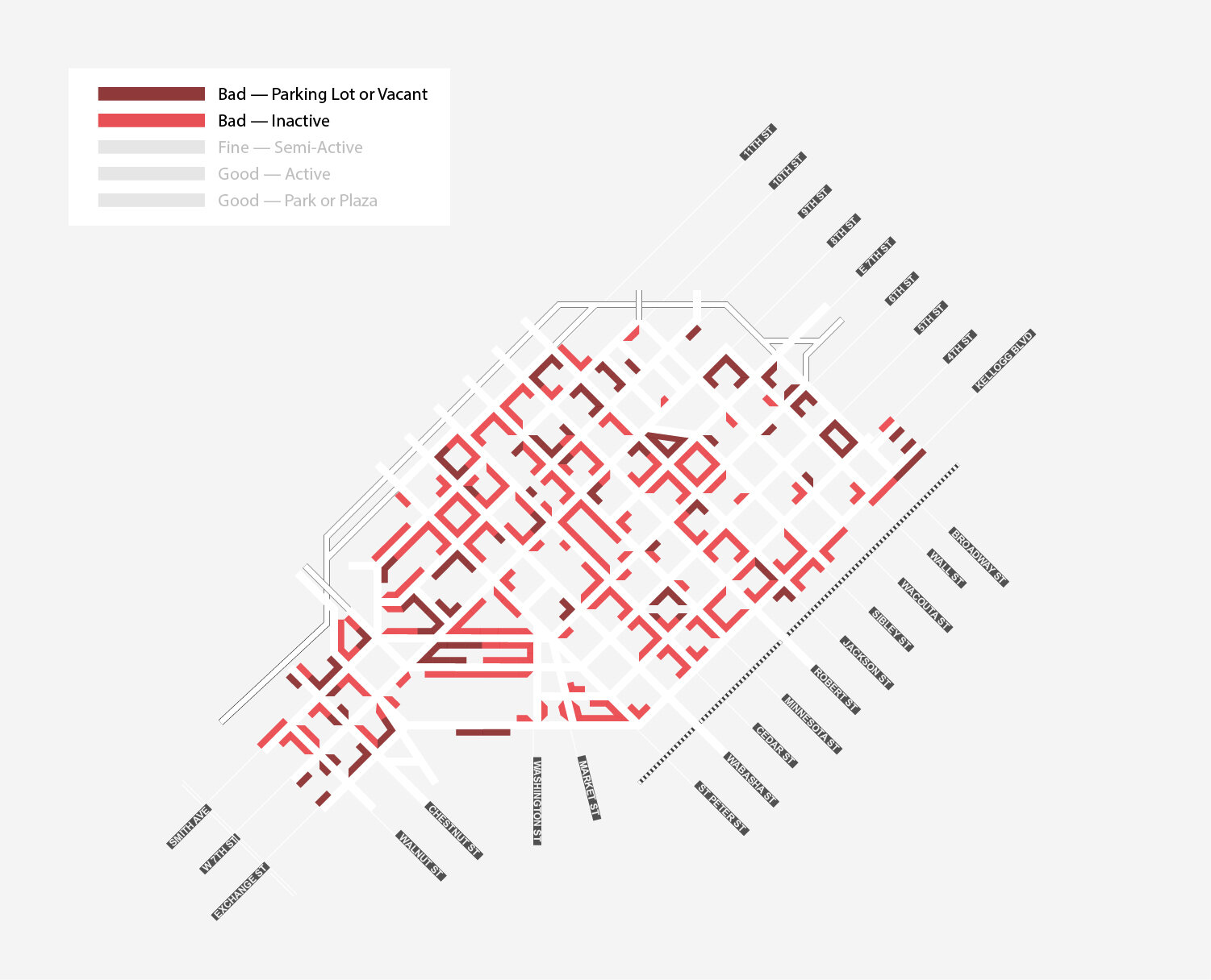
This is not for the faint of heart. Downtown St. Paul has block after block after block of inactive streetfronts or surface parking.
Bad streetfronts are especially prevalent west of Sibley Street. The worst carnage is along the west edge of Cedar Street or the northern edge of 9th Street. I submit that downtown St. Paul’s single worst intersection is at 9th and Minnesota.
St. Paul is especially harmed by a handful of large, multi-block office complexes. The UBS Tower of raccoon fame and its surrounding “Town Square” complex is one of the biggest offenders. But the worst of all is the Travelers/Ecolab complex that destroys two long blocks in the triangle formed by Washington, 6th and 7th Streets. Sitting directly next to the Landmark Center, this collection of offices, structured, and surface parking makes it nearly impossible for St. Paul to bring together the vibrancy of the Rice Park area and the West 7th area.
One of the tricky things about evaluating downtown St. Paul was that the problem is not always the building itself, but rather its configuration. To pick on the Town Square complex again, there are blocks of blank ground-floor window walls that probably could become retail spaces without a lot of investment. You can see this issue everywhere. I sometimes scored these specific streetscapes differently (an office with clear windows was graded fine, reflective windows were graded bad), but they have the same potential for a lot of cheap, transformative rennovations.
The reason this doesn’t happen is simple; a lack of demand. There are not enough residents or workers in downtown St. Paul to create the demand for active commercial streetfronts. The value of sustained investment in housing or employment (3M come home) to downtown St. Paul’s streetscapes could be multiplied if it leads to greater interest in retrofitting some existing ground floor spaces as well.
Short Term: Limited Options
Unfortunately, there’s not a great deal of development in the pipeline for downtown St. Paul. Recently two staid apartment buildings (we love staid apartment buildings), Oaks Union Depot and The Donegan were constructed near Union Depot. An apartment building called The Arlow was recently built on a surface parking lot near the Xcel Energy Center, and a hotel appears to be moving forward on the other half of the block after the initial construction was destroyed by arson. There have also been a handful of residential conversions of Class C office space—of which downtown St. Paul has no shortage—including the former Pioneer Press headquarters.

But despite an overall acceleration of housing production in St. Paul in past years, the downtown area has not seen the same kind of redevelopment interest as seen across the river in Minneapolis. There are just two sites of note, and a third that is in perpetual limbo:
Ramsey County tore down two riverside buildings near the Wabasha Street Bridge and prepared the site for a large scale redevelopment. The winner of their RFP was AECOM (this is where I note that I work for the same company, but have nothing whatsoever to do with the work of its Minnesota development arm) which proposed a massive, four-tower complex called Riversedge. This is an enormously complicated site and project, and the County and developer are asking the state legislature for financial assistance. If built, it would obviously be an absolutely transformative project, but there are so many questions that remain.
Right before the pandemic, the City of St. Paul released an RFP for their RiverCentre Ramp site. This is a city-owned parking ramp next to the RiverCentre events center and the Xcel Energy Center that is crumbling and in need of repairs. The City received a bunch of ambitious responses to their RFP, but as far as I can tell, nothing has been heard about the RFP and the site since. Certainly the City has been stretched by other priorities.
Pedro Park is a small, quarter-block patch of DIY green space in the northern part of downtown that is well-spaced from Mears and Rice Park. The park has one nice building next to it while the rest of the block is dross. The park and these other buildings have been the subject of a long and tortuous saga regarding redevelopment, further park development, and just about everything else imaginable. This area of downtown has approximately two nice retail buildings, both of which face the park, and so the redevelopment of the entire Pedro Park block could have a significant positive effect on its surroundings if it ever happens.
Long Term: WHAT’S Bad
One of the reasons why it’s a bit frustrating that downtown St. Paul’s main redevelopment projects are both moonshots is that there are a ton of available parcels that are a lot simpler and more centrally located:
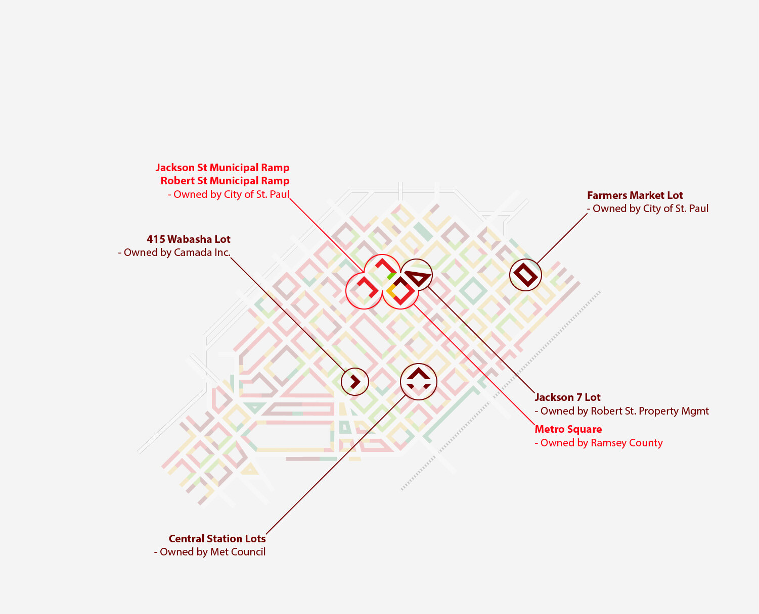
For my money, downtown’s most obvious candidate for redevelopment is the parking lot at 415 Wabasha, across from Amsterdam Bar Hall and the Treasure Island Center. Located right next to a ton of retail amenities and Rice Park, and within easy walking distance of most of the city’s office towers, this is would be the perfect location for a new housing development.
Directly across the street is the practice facility for the Minnesota Wild. I know via Instagram that Kirill Kaprizov, Kevin Fiala, and other stars for the team live in downtown Minneapolis. How is that not an incredible embarrassment to St. Paul? Are you telling me that these players wouldn’t love to live directly across the street from their practice rink if they had the opportunity? Mayor Carter should call up the principal of Camada Inc. every single day and ask him why this property isn’t developed yet.
The irregularly shaped parcels created by the Green Line LRT’s Central Station are in their eighth year of receiving absolutely no development attention. This is a site directly next to a major transit station in the heart of a business district. Where is the sense of urgency to put homes and businesses next door? Mayor Carter should call up Charlie Zelle every single day and ask him why this property isn’t developed yet.
Everyone loves the St. Paul Farmers Market, but here’s the thing: 93.5% of the time, this site is a surface parking lot in the middle of downtown’s best neighborhood. This is not the Mercado de Santa Caterina. It could be housing and permanent retail spaces. The Farmers Market could be moved to the front lawn of the Union Depot, or to Mears Park, or to CHS Field, or the city could just close some streets to make space for it. There is noting sacred about this parcel and the City should sell it to a developer for mixed income housing.
There are four adjacent downtown blocks on either side of East 7th Street between Sibley and Minnesota Streets that demonstrate the effect of one of the biggest entitites holding downtown St. Paul back: its own government.
I am apoplectic about the blue glass-clad Metro Square Building, which is a dual crime against architecture and urban design. It’s owned by Ramsey County and houses among other departments, the staff working on the Gold Line and Purple Line BRT projects. I have nothing against these transit planners, but the building they work in should be sold and redeveloped.
The City of St. Paul’s “Housing and Redevelopment Authority” owns two large parking structures on Jackson and Robert Street. This strikes me as deeply ironic, because what these two properties desperately need is some housing and redevelopment.
A private landowner controls a large surface parking lot at the spot where East 7th Street bends and confusingly remains 7th Street even though it is now on the line of 8th Street. I don’t know what this private company’s deal is, but they certainly can’t be inspired by the example of the publicly owned neighboring sites.
Look—St. Paul has to decide whether it wants to be in the city business or the parking business, because the latter is getting in the way of the former. Years ago, the City took an enormous risk with taxpayer money and bet on itself by developing the Penfield Apartments itself. That bet paid off and the city came out ahead. This is not always a wise thing to do, but even if the end result of the city’s direct investment is a small loss instead of a small gain, it can be a positive for the city overall when the end result is housing and retail (instead of, say, a convention center or a stadium). There is no shortage of City or County owned property in downtown St. Paul that could be redeveloped or sold for redevelopment today. Instead, local government is sitting in this property and mostly using it for parking. To a greater extent than in Minneapolis, downtown St. Paul is the way it is today because its governing authorities choose to keep it so.
Really LONG TERM: THE Surrounding Neighborhoods
Local government is not the only thing holding downtown St. Paul back. There is also the state and federal government. Downtown St. Paul is absolutely choked by interstate highways. Even worse, it’s not clear to me that capping the highway would have a significant effect. In downtown, once you cross the highway, there’s a wasteland on the other side in just about every direction. In contrast, in downtown Minneapolis, once you cross the highway, there’s usually a residential neighborhood on the other side.
Everyone talks about how difficult downtown St. Paul is to reach by walking or biking. This is the cause. It is surrounded not just by a highway moat, but by wide-open fields of fire beyond that. I think its next-door neighborhoods are an massively underrated issue for downtown St. Paul:
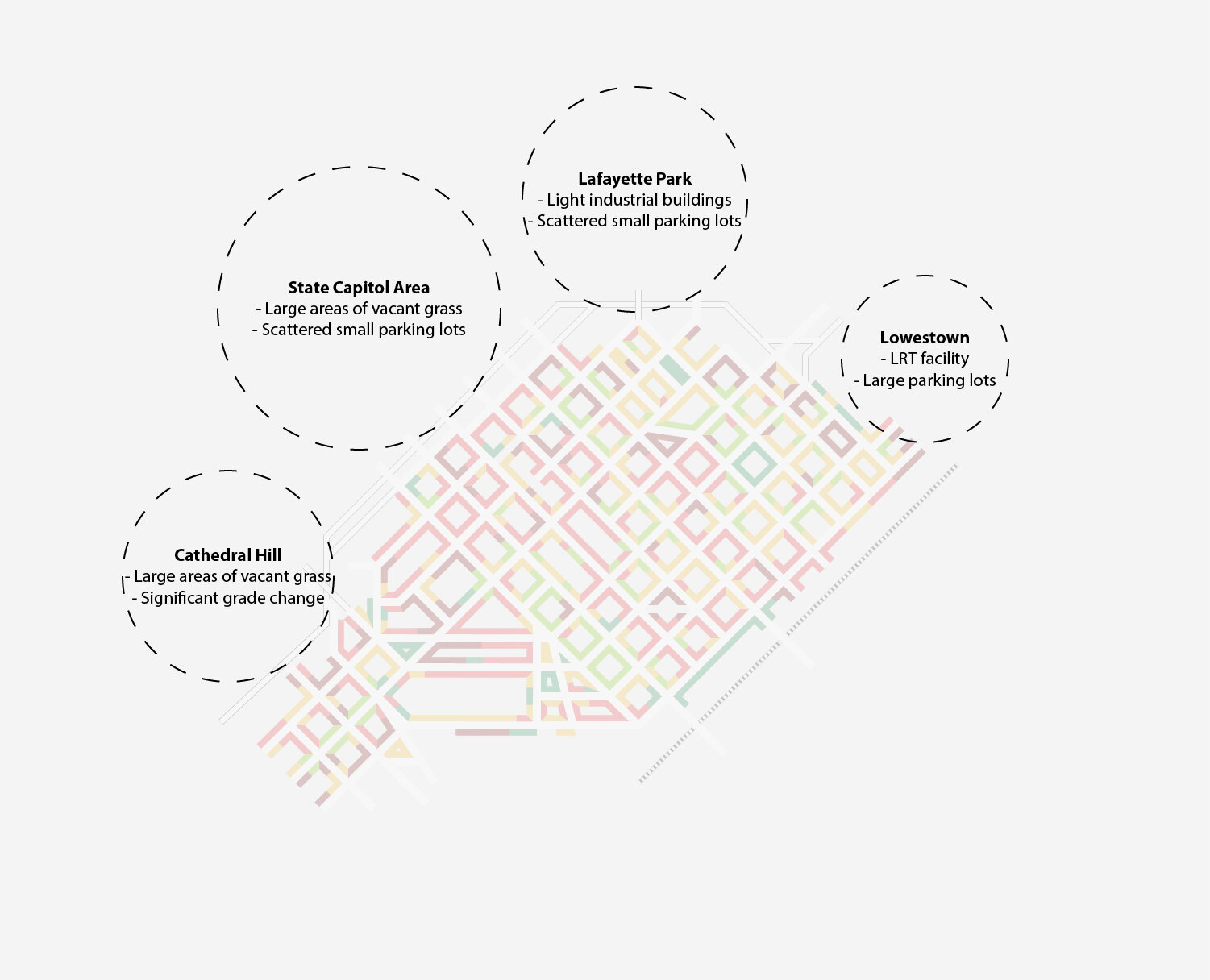
To the east, there is a long stretch of parking lots under freeway viaducts. To the northeast, there’s a weird light industrial and parking area called Lafayette Park which might be the most unknown area in the entire Twin Cities. To the north, there’s the State Capitol area, which is full of unfriendly government buildings, small parking lots, and vacant stretches of grass. Finally, to the northwest there’s Cathedral Hill, which is separated from downtown by an imposing hill and—you guessed it—more parking and vacant grass.
How to solve this?
The City should take an active interest in the parking lots beyond CHS Field and under the Lafayette Bridge. While a bit peripheral to the downtown area, it’s adjacent to Lowertown and close to amenities like the Bruce Vento Nature Sanctuary and Regional Trail. There’s no reason that this area wouldn’t be an attractive place to live and can’t be redeveloped, even if the Green Line maintenance facility adds an additional challenge. A master plan for this area that sets out such a vision would really help.
Lafayette Park (and Railroad Island beyond it) are really fascinating and out-of-the-way areas, despite being so close to the downtown area. Both are cut off from the rest of the city by highways, railroads, and Swede Hollow. This is an area where a little bit of TLC from the City could go a long way to putting this area on the map. The City could make it a lot easier to get to and through this area. There looks like ample space for protected bikeways on University Ave E, Lafayette Road, and the East 9th Street Bridge. In what might be a hopeful sign of the future for the area, a 6 story apartment building was recently proposed (thanks to Bill Lindeke for pointing this out to me) just across the highway from downtown, heightening the importance of making cosmetic changes in this area.
The State of Minnesota has absolutely stuck its thumb in the eye of St. Paul by allowing the Capitol grounds area to become a lifeless landscape of asphalt and crabgrass. Both John Ireland Boulevard and Cedar Street feature dull unplanted medians. The Veterans Service Building is flanked by two wings of surface parking lots. Maybe the State won’t let the Capitol area become a neighborhood again, but the least they could do is transform it into a park where people want to be. Planting a lot more trees in the area south of Rev. Dr. Martin Luther King Boulevard, especially along those medians, and replacing the surface parking lots along West 12th Street with gardens would solve a lot of issues.
Down the road, the area in the shadow of the St. Paul Cathedral is mostly lifeless thanks to highway interchanges and is difficult to redevelop thanks to the steep grade. Only a small pocket of apartments remains. If you look at a property map of this area, you’ll see that most of it is actually right-of-way owned by the state. One thing that they could do would be to more accurately plat the area, give up the surplus space, and allow it to become developable parcels again.
POST-PANDEMIC DOWNTOWN St. Paul
There are pessimistic and optimistic ways to look at the future of downtown St. Paul. Certainly it is a bit of an anachronism; a small-city downtown within a large metro area. In a time when office development seems concentrated either in downtown Minneapolis or along three-digit freeways, downtown St. Paul doesn’t have an obvious edge in competition with either. The pandemic’s effects on demand for office space are not fully understood yet, but it seems reasonable to expect that lower quality office space will struggle the most. This adds another disadvantage.
But on the flip side, a lot of the things holding St. Paul back are maybe(?) easier to address than they may seem. With public entities owning so much key land, the city has a bit more control over if and how it redevelops. St. Paul also has a lot of spaces that could become active and engaging with minor renovations, and a historic fabric that will always continue to draw in people. Upcoming transit investments will also make the area much more accessible to people across the region.
When I looked at downtown Minneapolis, I assumed a certain momentum towards redevelopment which was there for the shaping. With downtown St. Paul, the challenge is generating that momentum in the first place. Thanks to how much is already in municipal hands, shaping it is the easier part.